Papua or Irian Jaya

Papua (Indonesian: Provinsi Papua) is a province of Indonesia. It comprises most of the western half of the island of New Guinea and nearby islands. Its capital is Jayapura. It is the largest and easternmost province of Indonesia. The province originally covered the entire western half of New Guinea. In 2003, the Indonesian government declared the westernmost part of the island, around Bird’s Head Peninsula, a separate province; its name was first West Irian Jaya and is now West Papua: the remaining part retained the name, Province of Papua.

Naming

“Papua” is the official Indonesian and internationally recognised name for the province. During the Dutch colonial era the region was known as part of “Dutch New Guinea” or “Netherlands New Guinea”. Since its annexation in 1969, it became known as “West Irian” or “Irian Barat” until 1973, and thereafter renamed “Irian Jaya” (roughly translated, “Glorious Irian”) by the Suharto administration.[2][3] This was the official name until the name “Papua” was adopted in 2002. Today, natives of this province prefer to call themselves Papuans. The name “West Papua” was adopted in 1961 by the New Guinea Council until the United Nations Temporary Executive Authority (UNTEA) transferred administration to the Republic of Indonesia in 1963. “West Papua” has since been used by Papuans as a self-identifying term, especially by those demanding self-determination, and usually refers to the whole of the Indonesian portion of New Guinea. The other Indonesian province that shares New Guinea, West Irian Jaya, has been officially renamed as “West Papua”. Within Indonesia and West Papua itself, ‘Papua’ usually refers to the entire western half of New Guinea despite its division into separate provinces.Western New Guinea is generally referred to as ‘West Papua’ internationally – especially among networks of international solidarity with the West Papuan independence movement.

Geography

A central east-west mountain range dominates the geography of the island of New Guinea, over 1,600 km (994 mi) in total length. The western section is around 600 km (373 mi) long and 100 km (62 mi) across. The province contains the highest mountains between the Himalayas and the Andes, rising up to 4884 m high, and ensuring a steady supply of rain from the tropical atmosphere. The tree line is around 4000 m elevation and the tallest peaks contain permanent equatorial glaciers, increasingly melting due to a changing climate. Various other smaller mountain ranges occur both north and west of the central ranges. Except in high elevations, most areas possess a hot humid climate throughout the year, with some seasonal variation associated with the northeast monsoon season. The third major habitat feature are the vast southern and northern lowlands. Stretching for hundreds of km , these include lowland rainforests, extensive wetlands, savanna grasslands, and some of the largest expanses of mangrove forest in the world. The southern lowlands are the site of Lorentz National Park, also a UNESCO World Heritage Site.

The province’s largest river is the Mamberamo, sometimes called the “Amazon of Papua”, which winds through the northern part of the province. The result is a large area of lakes and rivers known as the Lakes Plains region. The famous Baliem Valley, home of the Dani people is a tableland 1600 m above sea level in the midst of the central mountain range; Puncak Jaya, sometimes known by its former Dutch name Carstensz Pyramid, is a mist covered limestone mountain peak 4884 m above sea level. It is the highest peak of Oceania.

Ethnic Groups

The following are some of the most well-known ethnic groups of Papua: Amungme, Asmat, Bauzi, Dani, Kamoro, Kombai, Korowai, Mee, Sentani, Yali, Yei

Papuan dance from Yapen
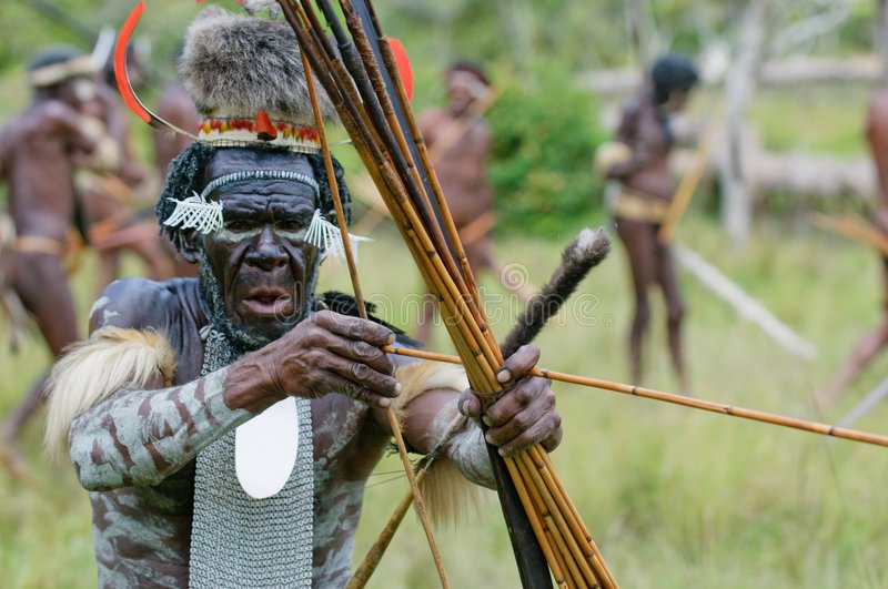
Yali Warrior

Sentani Dance

There are approximately 2,500 speakers of the Yei language. 40% Ethno Religionists- animistic tribal religion 60% Catholics and other Christians (blended with animistic beliefs & customs) The Yei language is believed to have 2 dialects observed by a Wycliffe, SIL language survey in 2001. At home the Yei people speak their own language but use Indonesian for trade, wider communication and at school. Most Yei are literate in Indonesian. The Yei people have no Bible translation, gospel films or videos in their language.

There are elementary schools in each village. About 10-30% of children continue in middle school. Very few go to high school. The nearest high school is in Merauke city. They live primarily by hunting, fishing, and gardening short and long term crops in the lowlands. The Yei diet mainly consists of rice, vegetables, fish and roasted sago. With their land at an altitude of less than 100 meters above sea level, the Yei people can best be accessed by vehicle on the road from Merauke or by motorized canoe up the Maro River. There is no airstrip or airplane access other than float plane which is currently available from Merauke through MAF by about a 15 minute flight to Toray. The Poo and Bupul villages have a clinic but people still use traditional medicines. There is very little infrastructure in the area: no telephones or toilets. At night electricity is run from a generator. There are (SSB’s) Single side-band radios in Bupul, Tanas, Poo, and Erambu villages, mainly used by the police and military force. Most villages get their drinking water from the Maro River, but some get it from wells or by collecting rain.

Demographics

The population of Papua province has been growing fast (2.9 children per woman fertility rate), from 1.9 million in the 2000 Indonesia Census to 2.9 million in the 2010 Census Since the early 1990s Papua has had the highest population growth rate of all Indonesian provinces at over 3% annually. This is partly a result of high birth rates, but mainly due to migration from other parts of Indonesia. While indigenous Papuans formed the near-totality of the population in 1961, they are now roughly 50% of the population,[citation needed] the other half being composed of non-Papuan migrants coming from other parts of Indonesia. An overwhelming percentage of these migrants came as part of a government-sponsored transmigration program.

According to the 2010 census, 83.15% of the Papuans identified themselves as Christian with 65.48% being Protestant and 17.67% being Roman Catholic. 15.89% of the population was Muslim and less than 1% were Buddhist or Hindu. There is also substantial practice of animism by Papuans.
The densest population center, other than the large coastal cities that house Indonesian bureaucratic and commercial apparatus, is located in and around the town of Wamena in the Palim (a.k.a. Baliem) Valley of the Central Highlands. The ‘extreme democracy’ and ecological stewardship of the highlands Papuan society is documented by Jared Diamond in the book Collapse: How Societies Choose to Fail or Succeed.

Shopping Basket
Scroll to Top
×